Plan Framework
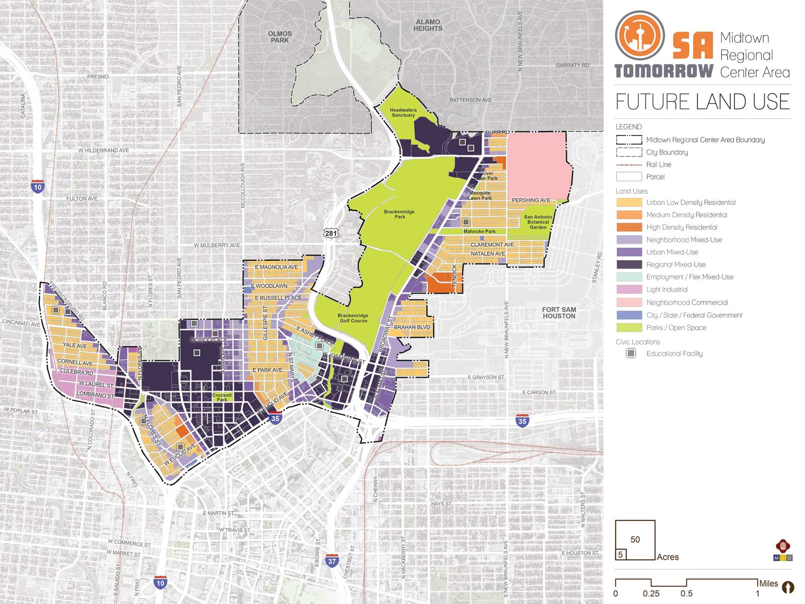
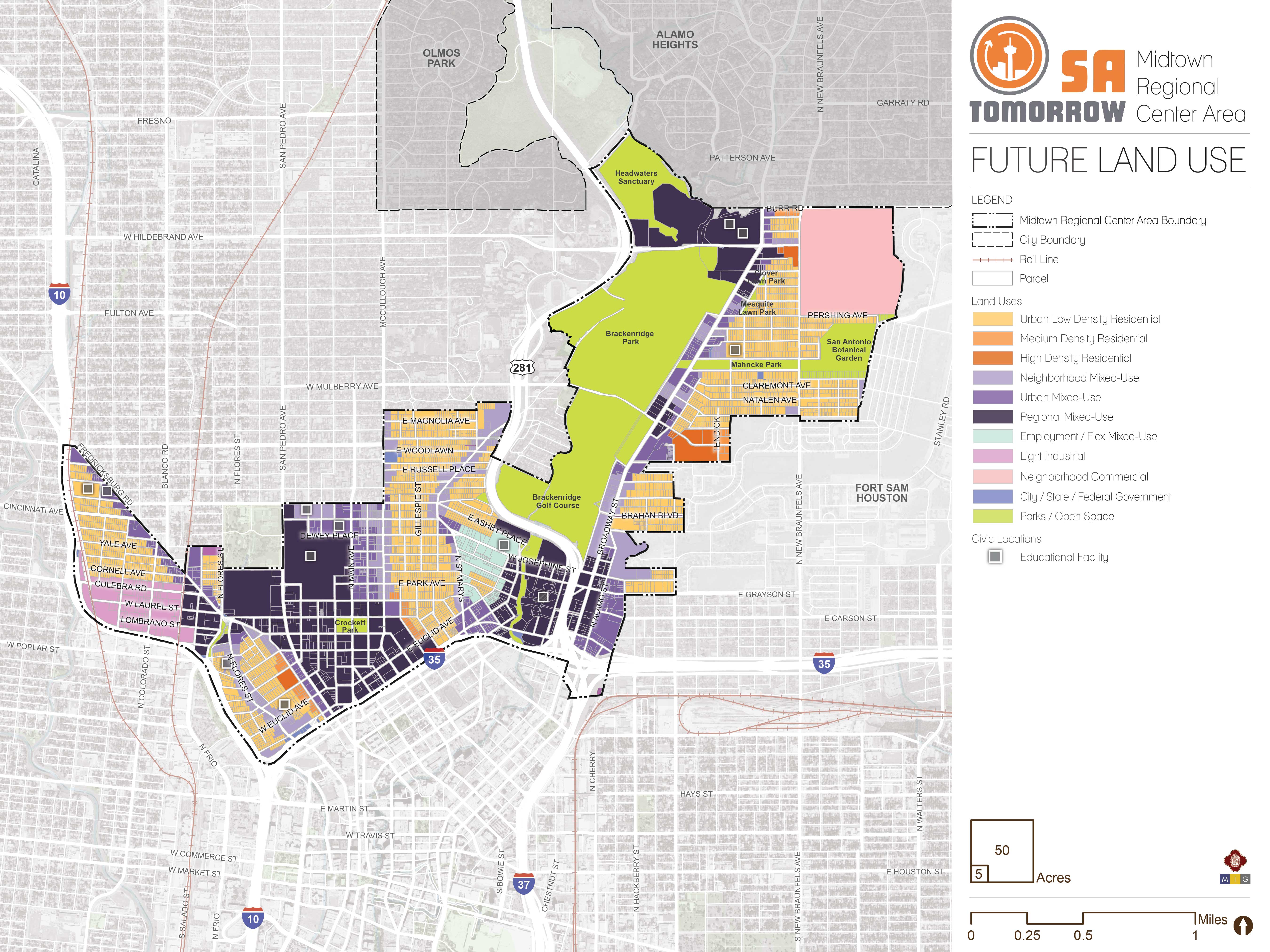
Land Use
The Midtown Area Regional Center land use plan supports the SA Tomorrow Comprehensive Plan, Multimodal Transportation Plan, and Sustainability Plan, draws on recommendations from the SA Corridors Strategic Framework Plan and implements the Vision, Goals, and Plan Framework for the Midtown area. The land use plan supports stability in neighborhoods and the anticipated evolution of unique places and destinations in centers and mixed-use corridors that are both anchored by, and mutually supportive of, great transit service and delightful outdoor places. Consequently, the land use map can be simply described as focusing on neighborhood areas, mixed-use areas, and a light industrial area.
NEIGHBORHOOD AREAS
Neighborhood areas, classified as Urban Low Density Residential or Medium Density Residential on the future land use map, are supposed to be primarily quiet, stable residential places that retain their character in the future. The land use plan provides for a modest amount of additional households to join these neighborhoods, primarily where the existing zoning would support such growth. Commercial businesses should typically not encroach into these areas in so much as they cause significant disruption to the ambience and quality of life and divert commercial activity from places where it is specifically desired.
MIXED-USE AREAS
Mixed-use areas, which are typically in focus areas or next to existing and planned transit corridors, major amenities or employment anchors, or existing commercial areas, are supposed to support a mix of business, jobs, shopping, services, and living. Each mixed-use area has unique qualities, potential, and constraints, and the land use plan reflects this by differentiating the three adopted mixed-use categories. The lowest intensity mixed-use land use category is Neighborhood Mixed-Use. This encourages smaller buildings in areas with fewer people and less activity, and is planned primarily for areas next to Flores Street, McCullough Avenue, St. Mary’s Street, and Ashby Street. The highest intensity mixed-use areas, which are intended to host the most people living, working, and recreating, are focused on portions of San Pedro Avenue; the two focus areas adjacent to San Pedro Avenue; and some areas adjacent to Broadway Street. These areas are designated as Regional Mixed-Use. An intermediate intensity mixed-use classification, Urban Mixed-Use, is proposed for much of Main Avenue, Fredericksburg Road, other areas adjacent to Broadway Street, and other selected nodes where VIA transit routes intersect one another.
The Employment/Flex Mixed-Use land use category is used throughout most of the San Antonio River Focus Area to create a place with a mix of light fabrication, studio spaces, residences, and offices.
Together the mixed-use areas will absorb development that would otherwise pressure neighborhoods, blue collar job areas, and natural resources, and instead support high quality transit service, great amenities and public spaces, and housing and economic opportunity for existing neighborhood residents and future generations.
LIGHT INDUSTRIAL AREAS
The area south of Culebra and west of San Marcos is proposed for the “Light Industrial” future land use and is intended to continue supporting existing businesses and blue collar jobs. In the long term, this area could serve as an industrial refuge to the extent that industrial uses remain viable and may support the Comprehensive Plan goal of adding new jobs to Regional Center areas. It is vital that this area continues to support the future job capture for this regional center as well as continue to assist in sustaining San Antonio’s dwindling industrial and blue collar heritage in the central city. Conversely, the area could also serve as a future bank of land that could accommodate substantial residential growth should a Sub-Area Plan update determine that additional residential growth capacity is needed. Incremental plan amendments and rezonings that allow residential uses to encroach in this area are discouraged.
Recommendation #1:
Initiate rezoning in selected mixed-use corridors and focus areas and update the Unified Development Code to support transit-oriented development, mixed-use corridors, and centers with a high quality public realm.Prior plans in the Midtown area, dating as far back as 2001, envisioned vibrant pedestrian and transit-oriented main street places in many of the same areas identified in this plan. However, due to a variety of factors, including, but not limited to, sub-optimal zoning and design standards, most recent examples of new development in these “mixed-use” areas are auto-oriented, single-use developments that do not contribute to the goals of previously adopted neighborhood plans, the SA Tomorrow Comprehensive Plan, and the Midtown Regional Center Plan.
Implementing the Midtown land use plan will require a coordinated approach to updating multiple sections of the Unified Development Code and to updating the zoning map in regards to mixed-use corridors and focus areas. New mixed-use and revised transit-oriented zoning districts should be written into the Unified Development Code and the City should lead in rezoning selected portions of focus areas and mixed-use corridors using these new zones. The new transit-oriented and mixed-use zoning should encourage vertical mixed-use development, with public-facing commercial activity on ground floors, and offices and/or residences above. New automobile-oriented uses and site designs should be discouraged or prohibited in these zoning categories.
Successful and vibrant retail areas featuring significant pedestrian activity and a diverse mix of business and services rely on a substantial population to support them. Their success also relies on businesses being sufficiently concentrated, rather than overly spread out across long travel corridors, interspersed with vacant areas and abundant surface parking areas. Accordingly, to activate underused places, meet the city’s housing goals, and encourage concentrated vibrant commercial areas, multifamily residential development is encouraged in mixed-use corridors and focus areas.
Apart from regulating uses, the Unified Development Code (UDC) also regulates design, building forms, tree planting and preservation, parking, driveways, and more. Regulations on each of these topics have contributed to the current built environment and mix of uses in Midtown and the ongoing prevalence of new auto-oriented development. The UDC should be optimized to reflect the guidance provided by the SA Tomorrow Comprehensive Plan and the emerging vision from each SA Tomorrow Sub-Area Plan.
Recommendation #2:
Encourage zoning that supports the maintenance of neighborhood character while encouraging affordable housing, housing for all stages of life, and housing that is accessible to people with mobility impairments.Maintaining and creating new housing that is accessible to people with disabilities, affordable to lower income households, and useful for larger households is necessary to support the Midtown Vision and Goals.
Taken together with Midtown and other city goals to maintain the physical character of inner city neighborhoods, there may be an opportunity to create a new combination of residential design and zoning standards, that ensure the physical form of new neighborhood residential construction is consistent with local character, while removing barriers to the creation of new housing and rehabilitation of existing housing that is diverse, accessible, and affordable. For example, in residential areas where physical form is not already protected by a neighborhood conservation district or historic district, more conservative limits on setbacks, floor area ratio, height, or lot coverage can ensure consistency with existing neighborhood character, while allowing a marginal increase in the number of allowed dwelling units that support housing supply, affordability, and diversity goals.
A planning process that involves all relevant stakeholders, multiple agencies and experts, and design professionals will be needed to explore this concept and develop Unified Development Code updates based on the findings and community input. It would be potentially applicable to multiple inner city areas, so accordingly would involve a wide range of community representatives, and should be informed by additional sub-area planning efforts in coming years, rather than implemented as a short term follow-up action to only the Midtown Regional Center Plan.
A residential infill design competition showcasing several desired housing types in typical inner city residential contexts would complement the technical investigation as well as the community conversations on what kinds of physical design outcomes would be comfortable for neighborhood residents. Multiple ongoing community conversations are already generating ideas that could inform this effort, including the Mayor’s Housing Policy Taskforce, and design workshops hosted by the Office of Historic Preservation and partner design firms.
Recommendation #3:
Discourage incremental rezoning (both up zoning and down zoning) in Midtown neighborhood areas.Neighborhood stability, ensuring adequate housing supply, and fostering vibrant, pedestrian-oriented commercial areas are important elements of this plan. In Midtown, there is substantial supply of land available for commercial uses in mixed-use corridors and focus areas; however, there is a forecast need for several thousand additional housing units by 2040. Accordingly, new, incompatible commercial uses in neighborhood residential areas are discouraged.
To support stability, predictability, and modest growth in housing supply and choice within neighborhood areas, down-zoning residential properties to restrict housing unit density and exclude potential future neighborhood residents is discouraged. Similarly, changing the base zone of residentially zoned properties in neighborhood residential areas to allow more density is also discouraged.
Where additional households or uses beyond those currently allowed may be appropriate, conditional rezoning is a mechanism that provides more certainty as to development outcomes and the future evolution of a property. Accordingly, to support stability and predictability while supporting other community goals, such as incenting affordable housing, housing for people with disabilities, housing with multiple bedrooms for families, and reinvestment in existing structures that contribute to the essential character of a neighborhood, conditional rezoning is preferred to changing base rezoning in neighborhood residential areas.
Similarly, to implement the recommendations of the Mayor’s Housing Policy Taskforce to incent certain types of housing, some combination of Unified Development Code amendments and rezoning in neighborhood residential areas that simultaneously encourages more housing for people, while providing more certainty on building and site design is encouraged.
Rezoning individual properties from MF-33 is supported in order to ensure building forms and site designs that are consistent with neighborhood character if the rezone does not reduce the number of allowed dwellings on the site.
Recommendation #4:
Land use decisions should support the continued use or adaptive-reuse of existing structures that contribute to the essential character of Midtown.Mixed-use areas include clusters of small historic landmark buildings or existing buildings that contribute to the essential character of the area. Historic pockets occur, for example, adjacent to Fredericksburg Road, between Cincinnati and Craig Place near the intersection of Lewis and Poplar Streets, as well as other locations throughout Midtown’s future mixed-use areas. Several resources can be used to understand the character of these places and the buildings in them, including Office of Historic Preservation historic resource surveys and inventories, neighborhood conservation district inventories, and previously adopted plans. To make maintenance and rehabilitation of these structures financially viable, profitable uses of these structures to the greatest intensity feasible is encouraged.
Future Land Use Categories
As described above, the Midtown Regional Center Plan includes a range of land use designations that represent the unique character of the area, while encouraging and supporting development patterns that reflect the goals of the SA Tomorrow Comprehensive Plan and the preferences of the Midtown community. Listed below is the full list of land use categories adopted by City Council into the Unified Development Code (UDC), Chapter 35, on October 11, 2018. Each category listed includes a description, general guidance on where the land use designation is most appropriate, and a list of allowable zoning districts.
Residential Estate
Includes large lot single-family detached houses on individual estate-sized lots or in conservation subdivisions. This form of development should be located away from major arterials, and can include certain nonresidential uses such as schools, places of worship, and parks that are centrally located for convenient neighborhood access. Permitted zoning districts: FR, R-20, RE, and RP.
- Typical densities in this land use category would be up to 2 dwelling units per acre.
Low Density Residential

Regional Mixed-Use
- IDZ, PUD, MXD, TOD and MPCD may be considered consistent with this land use category, provided the permitted uses included on the zoning site plan and zoning ordinance are consistent with the uses and densities outlined above.
Employment/Flex Mixed-Use
.jpg)
- IDZ, PUD, MXD, TOD and MPCD may be considered consistent with this land use category, provided the permitted uses included on the zoning site plan and zoning ordinance are consistent with the uses and densities outlined above.
Business/Innovation Mixed-Use
Accommodates industrial uses with office, commercial, and residential uses, all within a cohesive setting, on a larger scale and within larger footprints than the Employment/Flex Mixed-Use category. Industrial arts workshops, high tech fabrication, processing and assembly, and other industrial uses are permitted, in addition to commercial uses. Vocational training, technological learning centers, medical campuses, and research/development institutions are also appropriate for these spaces. Additional environmental performance standards should be employed for properties designated as Business/Innovation Mixed-Use, such as hours of activity, loading, noise levels and lighting, to ensure that the intensity of the industrially oriented uses is comparable to that of the other non-residential uses. The mix of uses may be either vertically or horizontally distributed. Live/work housing options are permissible in Business/Innovation Mixed Use areas to ensure access to housing options and services within close proximity of business innovation areas for the local-workforce. Business/Innovation mixed use should incorporate transit and bicycle facilities to serve the training and employment base. Permitted zoning districts: RM-4, MF-18, MF-25, O-1.5, O-2, C-2, C-3, L, I-1, MI-1, BP, AE-1, AE-2, AE-3, and AE-4.
- IDZ, PUD, MXD, TOD and MPCD may be considered consistent with this land use category, provided the permitted uses included on the zoning site plan and zoning ordinance are consistent with the uses and densities outlined above.
Light Industrial
Includes a mix of manufacturing uses, business park, and limited retail/service uses that serve the industrial uses. Industrial uses should be screened and buffered from adjoining non-industrial uses. Any outside storage should be under a roof and screened from public view. Examples of light industrial uses include drug laboratories, furniture wholesalers, lumberyards, food production, and warehousing. Permitted zoning districts: L, I-1, MI-1, and BP.
- IDZ, TOD, and MPCD may be considered consistent with this land use category, provided the permitted uses included on the zoning site plan and zoning ordinance are consistent with the uses and densities outlined above.
Heavy Industrial
Includes heavy manufacturing, processing and fabricating businesses. Heavy industrial uses shall be concentrated at arterials, expressways, and railroad lines. This category is not compatible with neighborhood-scaled categories or those that permit residential zoning. Heavy Industrial should be separated from non-industrial uses by an allowable land use or a significant buffer. Examples of heavy industrial uses include auto manufacturing, battery manufacturing, and petro chemical bulk storage. Permitted zoning districts: I-1, I-2, MI-1, MI-2, QD, and SGD.
Agricultural
Includes crop agriculture, ranching, and related agribusiness practices. Single-family detached houses and detached accessory dwelling units are permitted on agricultural and ranch lands at very low densities or in conservation subdivisions that will not interfere with agricultural operations. Limited commercial uses directly serving agricultural and ranching uses, such as farmers markets, nurseries, stables, bed and breakfasts are permitted. To maintain scenic qualities, natural vegetative buffers, deeper setbacks, increased signage control, earthen drainage channels, and more restrictive access management standards are desired along major scenic corridors. Floodplain protection and buffer zones along creeks and rivers are instrumental in retaining rural character. Permitted zoning districts: RP and FR.
Parks/Open Space
May include, but is not limited to, large, linear, or unimproved land where conservation is promoted and development is not encouraged due to the presence of topographic constraints or institutional uses on the site. Parks/Open Space may include utility corridors and public or private land uses that encourage outdoor passive or active recreation. Examples include city owned and/or operated pocket, regional, or linear parks, as well as private parks associated with subdivisions and neighborhood associations.
City/State/Federal Government
Includes areas owned and operated by a federal, state, or city agency. Examples may include government offices, public service facilities such as libraries and police stations, military bases, state colleges, and federal courts. This category does not apply to properties owned by a public agency but leased to and operated by another party.